TUCA DE POSSOLOBINO
Contributed by David Sellars
FACTS
Country: Spain
Location: Benasque
Round trip: 8 km
Start elevation: 1910 m
Final Elevation: 2783 m
Maps: 1:25,000 Aneto Maladeta E 25 Editorial Alpina
GETTING THERE
From Benasque take the road to Cerler and continue on the the ski area at L’Ampriu
PARTIAL PLANT LIST
Dactyloriza fuchsii
Paradisea liliastrum
Myosotis alpestris
Myosotis alpina
Trollius europaeus
Asphodelus albus
Anemone narcissiflora
Gentiana lutea
Gentiana verna
Pulsatilla alpina
Androsace villosa
Viola tricolor
Arenaria tetraquetra
Adonis pyrenaica
Saxifraga oppositifolia
Saxifrage exarata
Saxifrage paniculata
Daphne cneorum
Primula integrifolia
Ornithogalum umbellatum
Phyteuma pyrenaica
Ranunculus parnassifolius


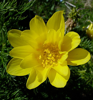
This is a fantastic hike for the variety and beauty of the flora. From the car park at the L’Ampriu ski area, hike up the gravel road below the lift line to the south east. The flora in the meadows is very rich including Paradisea liliastrum, Anenome narcissiflora, Trollius europaeus, Dactylorhiza fuchsii, Gentiana lutea and Ornithogalum umbellatum. At about 2100 m beautiful fields of Adonis pyrenaica, a Pyrenean endemic, decorate the slopes to the south. At the Collada de Baciver turn north and follow a faint path up the broad grassy ridge of Tuca de Possolobino.
In the fellfields at about 2350 m, the cushions of Androsace villosa and Arenaria tetraquatra are so frequent it is hard to avoid stepping on them. The ridge becomes narrower and rocky higher up and climbing some steep, stony sections, the west ridge of Tuca de Possolobino is gained with Gentiana verna and Primula integrifolia among the rocks. The summit is reached climbing over slabby rocks and Saxifraga oppositifolia, Myosotis alpina and Potentilla pyrenaica can be found near the highest point. The descent is by the same route.
TUCA DE POSSOBOLINO GALLERY.
The photos were taken on July 5, 2007
Click the arrows to start the slideshow or click on an image to expand.


