PORT DE BOUCHARO
Contributed by David Sellars
FACTS
Country: France
Location: SW of Gavarnie
Round trip: 5 km
Start elevation: 2208 m
Final Elevation: 2400 m
Maps: 1:50,000 gavarnie-ordesa Rando Editions, Sheet 24
GETTING THERE
Drive up the paved road from Gavarnie marked as D923 to the car park on the Col de Tentes.
PARTIAL PLANT LIST
Androsace primuliflora
Ranunculus alpestris
Linaria alpina
Primula integrifolia
Saxifraga exarata
Saxifraga oppositifolia
Saxifraga paniculata
Androsace ciliata
Salix reticulata
Gentiana alpina
Htchinsia alpina
Veronica nummularia
Geranium cinereum
Arenaria purpurescens


This hike explores the rich flora in the vicinity of the Col de Boucharo and does not involve a great deal of walking. From the car park at Col de Tentes head towards the Col de Boucharo on a paved road no longer accessible by cars. Pick your way around rock slides originating from the shattered cliffs on the north side of the road. The cliffs display some interesting plants including Vitaliana primuliflora and Saxifraga paniculata. The paved section ends at the Col de Boucharo and a gradually ascending trail rises across the southern slopes of Pic de Gabietou towards the Refuge de la Breche de Roland. The trail crosses talus slopes with large sandstone blocks interspersed with outcrops of limestone.
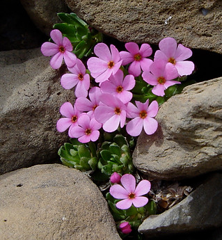
In the talus above the trail, mats of Androsace ciliata can be found, a beautiful plant with a very limited range. There were only a couple of plants in flower on July 1 2007. Saxifraga oppositifolia was in flower, however, in the talus and on the limestone outcrops. The sandstone boulders are worth exploring for Salix reticulata, Veronica nummularia and Androsace ciliata. In crevices in the limestone rocks Ranunculus alpestris and Saxifraga moschata can be found.
Returning to Col de Boucharo it is worth ascending the ridge on the other side towards Pic entre les Ports. Two Pyrenean endemics can be found just above the pass, Geranium cinereum and Arenaria purpurescens.
PORT DE BOUCHARO GALLERY.
The photos were taken on July 1, 2007
Click the arrows to start the slideshow or click on an image to expand.


